
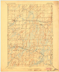
1896 Map of Sun Prairie
USGS Topo · Published 1896About this map
Glacial drumlins and extensive wetlands define the landscape between Sun Prairie and Cambridge in this late nineteenth-century survey of eastern Dane County. The terrain is dominated by the north-south orientation of glacial ridges, which dictated the winding paths of local waterways like Waterloo Creek and Koshkonong Creek. This drainage pattern created significant marshlands, particularly around Goose Lake and Mud Lake.
Find a feature on this map
41 named features on this map. Tap any name to fly to it.
Don’t see what you’re looking for? This feature index may not catch every label — zoom into the map to look around manually.
Map Details
Editions of this 1896 Sun Prairie Map
2 editions found
Other maps of this area

1889 · Evansville
USGS Topo · 1:62,500

1890 · Madison
USGS Topo · 1:62,500

1890 · Sun Prairie
USGS Topo · 1:62,500

1890 · Stoughton
USGS Topo · 1:62,500

1891 · Waterloo
USGS Topo · 1:62,500

1891 · Koshkonong
USGS Topo · 1:62,500

1892 · Madison
USGS Topo · 1:62,500

1894 · Waterloo
USGS Topo · 1:62,500

1894 · Evansville
USGS Topo · 1:62,500

1894 · Koshkonong
USGS Topo · 1:62,500