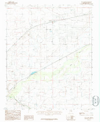
1986 Map of Sun Valley
USGS Topo · Published 1986About this map
Sun Valley sits at the heart of this Navajo County landscape, where the transport corridor of the Atchison Topeka and Santa Fe railroad and Interstate 40 dictates the local development pattern. The map reveals the confluence of high-desert drainage systems, as the Puerco River winds through sandy washes toward its junction with the Little Colorado River in the southwestern corner. While the settlement at Sun Valley appears relatively sparse, the infrastructure of the mid-1980s is evident through features like the Sewage Disposal Pond and a network of 4wd tracks that provide access to the surrounding arid terrain. Small-scale water management is visible in the form of a Check Dam, hinting at the ongoing efforts to manage the occasional heavy flows of the desert rivers. The rail siding at Arntz further illustrates the historical importance of the railroad to this northern Arizona region.
Find a feature on this map
10 named features on this map. Tap any name to fly to it.
Don’t see what you’re looking for? This feature index may not catch every label — zoom into the map to look around manually.
Map Details
Editions of this 1986 Sun Valley Map
This is the sole edition of this map. No revisions or reprints were ever made.
Other maps of this area

1883 · Tusayan
USGS Topo · 1:250,000

1886 · St Johns
USGS Topo · 1:250,000

1886 · Tusayan
USGS Topo · 1:250,000

1886 · Fort Defiance
USGS Topo · 1:250,000

1886 · Holbrook
USGS Topo · 1:250,000

1892 · Fort Defiance
USGS Topo · 1:250,000

1892 · St Johns
USGS Topo · 1:250,000

1893 · Holbrook
USGS Topo · 1:250,000

1912 · Petrified Forest
USGS Topo · 1:62,500

1947 · Flagstaff
USGS Topo · 1:250,000