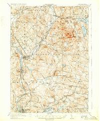
1921 Map of Suncook
USGS Topo · Published 1931About this map
The Merrimack River and the Suncook River converge at the industrial village of Suncook, defining a landscape where river-powered manufacturing and early rail corridors meet the uplands. This 1921 survey illustrates a transition from the dense mills and residential blocks of Allenstown and Pembroke to the rural schools and family-named hilltops of Candia and Epsom. The transportation network is remarkably detailed, featuring the Suncook Valley RR alongside the Concord and Manchester Electric Road, indicating the peak of the interurban trolley era. Notable landmarks like the Sanitarium near Pembroke Hill and the State Rifle Range at Mt Miner highlight the institutional and military uses of the surrounding terrain. For researchers, the map provides precise locations for dozens of rural institutions, from the New Orchard School in the north to the Candia Post Office and Station in the south.
Find a feature on this map
153 named features on this map. Tap any name to fly to it.
Don’t see what you’re looking for? This feature index may not catch every label — zoom into the map to look around manually.
Map Details
Editions of this 1921 Suncook Map
5 editions found
Other maps of this area

1888 · Haverhill
USGS Topo · 1:62,500

1890 · Haverhill
USGS Topo · 1:62,500

1893 · Haverhill
USGS Topo · 1:62,500

1905 · Manchester
USGS Topo · 1:62,500

1906 · Milford
USGS Topo · 1:62,500

1917 · Mt. Pawtuckaway
USGS Topo · 1:62,500

1919 · Mt. Pawtuckaway
USGS Topo · 1:62,500

1919 · Gilmanton
USGS Topo · 1:62,500

1919 · Alton
USGS Topo · 1:62,500

1921 · Suncook
USGS Topo · 1:62,500