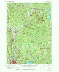
1957 Map of Suncook
USGS Topo · Published 1972About this map
The Suncook River and Merrimack River serve as the primary corridors for development through central New Hampshire, where textile mills and rural settlements once defined the landscape. This mid-century survey captures the region as it transitions from its early industrial roots to a modern landscape, featuring the dense village of Suncook and the institutional presence of Pembroke Academy and St Mary College. The vast Bear Brook State Forest dominates the center of the sheet, preserving a large swathe of terrain between the growing river towns and the upland farming communities of Epsom and Candia. To the south, the expansion of Manchester begins to influence the rural outskirts, while the Boston and Maine railroad tracks still follow the river valley. Traces of early educational history are preserved through labels for the North Road Sch and Candia Hill Sch, reflecting a time when small rural schoolhouses served the outlying districts of Horse Corner and New Rye.
Find a feature on this map
107 named features on this map. Tap any name to fly to it.
Don’t see what you’re looking for? This feature index may not catch every label — zoom into the map to look around manually.
Map Details
Editions of this 1957 Suncook Map
4 editions found
Other maps of this area

1888 · Haverhill
USGS Topo · 1:62,500

1890 · Haverhill
USGS Topo · 1:62,500

1893 · Haverhill
USGS Topo · 1:62,500

1905 · Manchester
USGS Topo · 1:62,500

1906 · Milford
USGS Topo · 1:62,500

1917 · Mt. Pawtuckaway
USGS Topo · 1:62,500

1919 · Mt. Pawtuckaway
USGS Topo · 1:62,500

1919 · Gilmanton
USGS Topo · 1:62,500

1919 · Alton
USGS Topo · 1:62,500

1921 · Suncook
USGS Topo · 1:62,500