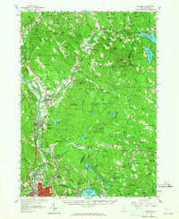
1957 Map of Suncook
USGS Topo · Published 1965About this map
The Suncook River flows south through a landscape of granite hills and evolving industrial villages just before the expansion of the regional highway system. This 1957 revision of earlier surveys captures the transitional character of eastern Merrimack and western Rockingham counties, where traditional river-powered settlements like Suncook and Hooksett stand in contrast to the burgeoning development around Manchester. The map documents a significant educational and civic footprint, from the grounds of Mt St Mary College to the State Industrial Sch, reflecting the institutional history of the corridor.
Find a feature on this map
128 named features on this map. Tap any name to fly to it.
Don’t see what you’re looking for? This feature index may not catch every label — zoom into the map to look around manually.
Map Details
Editions of this 1957 Suncook Map
4 editions found
Other maps of this area

1888 · Haverhill
USGS Topo · 1:62,500

1890 · Haverhill
USGS Topo · 1:62,500

1893 · Haverhill
USGS Topo · 1:62,500

1905 · Manchester
USGS Topo · 1:62,500

1906 · Milford
USGS Topo · 1:62,500

1917 · Mt. Pawtuckaway
USGS Topo · 1:62,500

1919 · Mt. Pawtuckaway
USGS Topo · 1:62,500

1919 · Gilmanton
USGS Topo · 1:62,500

1919 · Alton
USGS Topo · 1:62,500

1921 · Suncook
USGS Topo · 1:62,500