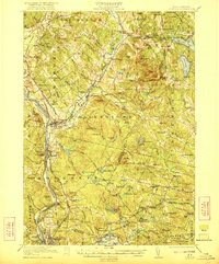
1921 Map of Suncook
USGS Topo · Published 1921About this map
The Merrimack River and Suncook River define the industrial and transit corridors of this region during the early twentieth century. Extensive rail infrastructure, including the Boston and Maine Railroad, Suncook Valley RR, and the Concord and Manchester Electric Road, connects major hubs like Suncook and Hooksett. The landscape is a mix of river-valley industry and upland farmsteads, evidenced by a dense network of local landmarks such as the Brickyard and the Sanitarium near Pembroke.
Find a feature on this map
132 named features on this map. Tap any name to fly to it.
Don’t see what you’re looking for? This feature index may not catch every label — zoom into the map to look around manually.
Map Details
Editions of this 1921 Suncook Map
5 editions found
Other maps of this area

1888 · Haverhill
USGS Topo · 1:62,500

1890 · Haverhill
USGS Topo · 1:62,500

1893 · Haverhill
USGS Topo · 1:62,500

1905 · Manchester
USGS Topo · 1:62,500

1906 · Milford
USGS Topo · 1:62,500

1917 · Mt. Pawtuckaway
USGS Topo · 1:62,500

1919 · Mt. Pawtuckaway
USGS Topo · 1:62,500

1919 · Gilmanton
USGS Topo · 1:62,500

1919 · Alton
USGS Topo · 1:62,500

1921 · Suncook
USGS Topo · 1:62,500