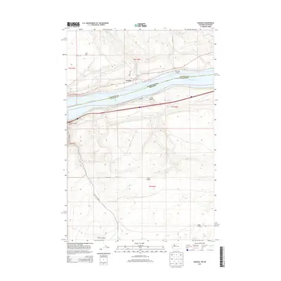
2013 Map of Sundale
USGS Topo · Published 2013About this map
The Columbia River serves as the dominant geographical and political boundary here, separating Klickitat County, Washington, from Gilliam County, Oregon. On the northern banks, the small settlement of Sundale sits near the mouth of Chapman Cr, where local routes like Conley Ln and the historic Old Highway 8 meet the primary corridor of Wa-14. This landscape is defined by its deep drainage systems, including Old Lady Canyon and the curiously named upland area known as The Burn. Across the water in Oregon, the terrain rises sharply into the high plateaus, carved by Blalock Canyon and Lang Canyon. The presence of Frontage Rd and Woelpern Rd suggests a network of rural access points supporting the agricultural and transit infrastructure along this vital river corridor in the early 21st century.
Find a feature on this map
22 named features on this map. Tap any name to fly to it.
Don’t see what you’re looking for? This feature index may not catch every label — zoom into the map to look around manually.
Map Details
Editions of this 2013 Sundale Map
This is the sole edition of this map. No revisions or reprints were ever made.
Other maps of this area

1916 · Arlington
USGS Topo · 1:125,000

1953 · The Dalles
USGS Topo · 1:250,000

1956 · The Dalles
USGS Topo · 1:250,000

1957 · The Dalles
USGS Topo · 1:250,000

1962 · Wood Gulch
USGS Topo · 1:24,000

1964 · Turner Butte
USGS Topo · 1:24,000

1964 · Shutler Flat
USGS Topo · 1:24,000

1964 · Mc Donald
USGS Topo · 1:24,000

1965 · Goodnoe Hills
USGS Topo · 1:24,000
1965 · Dot
USGS Topo · 1:24,000