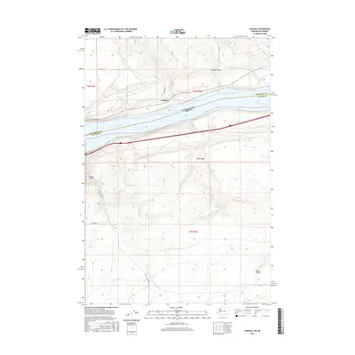
2017 Map of Sundale
USGS Topo · Published 2017About this map
Sundale sits prominently on the northern banks of the Columbia River, a focal point for this section of the Washington-Oregon border. The landscape is defined by the expansive Lake Umatilla, which fills the river valley between Klickitat Co and Gilliam Co. Inland, the terrain is deeply incised by a series of dramatic drainages, including Old Lady Canyon, Lang Canyon, and the extensive Blalock Canyon system. This 2017 survey illustrates the intersection of modern transportation and natural geography, showing how Old Hwy 8 and Sundale Rd navigate the steep rises above the water. Small seasonal flows like Chapman Creek provide the primary relief in an otherwise arid, bench-like topography that stretches toward Jones Canyon at the eastern edge of the quadrangle.
Find a feature on this map
18 named features on this map. Tap any name to fly to it.
Don’t see what you’re looking for? This feature index may not catch every label — zoom into the map to look around manually.
Map Details
Editions of this 2017 Sundale Map
This is the sole edition of this map. No revisions or reprints were ever made.
Other maps of this area

1916 · Arlington
USGS Topo · 1:125,000

1953 · The Dalles
USGS Topo · 1:250,000

1956 · The Dalles
USGS Topo · 1:250,000

1957 · The Dalles
USGS Topo · 1:250,000

1962 · Wood Gulch
USGS Topo · 1:24,000

1964 · Turner Butte
USGS Topo · 1:24,000

1964 · Shutler Flat
USGS Topo · 1:24,000

1964 · Mc Donald
USGS Topo · 1:24,000

1965 · Goodnoe Hills
USGS Topo · 1:24,000
1965 · Dot
USGS Topo · 1:24,000