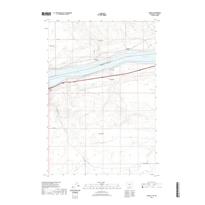
2020 Map of Sundale
USGS Topo · Published 2020About this map
The Sundale settlement occupies a narrow terrace on the northern shore of the Columbia River, situated at the convergence of rugged canyon terrain and the expansive waters of Lake Umatilla. This modern survey documents the boundary between Klickitat County, Washington, and Gilliam County, Oregon, a divide defined by the river’s path. The landscape is carved by deep drainages including Old Lady Canyon, Lang Canyon, and the extensive Blalock Canyon, which dominate the topography south of the river. Transportation corridors follow the natural contours of the land, with Sundale Rd and Old Hwy 8 providing access to the higher elevations above the water. Small tributaries like Chapman Cr feed into the main river system, illustrating the drainage patterns that have shaped this high-desert environment over generations of settlement and land use.
Find a feature on this map
13 named features on this map. Tap any name to fly to it.
Don’t see what you’re looking for? This feature index may not catch every label — zoom into the map to look around manually.
Map Details
Editions of this 2020 Sundale Map
This is the sole edition of this map. No revisions or reprints were ever made.
Other maps of this area

1916 · Arlington
USGS Topo · 1:125,000

1953 · The Dalles
USGS Topo · 1:250,000

1956 · The Dalles
USGS Topo · 1:250,000

1957 · The Dalles
USGS Topo · 1:250,000

1962 · Wood Gulch
USGS Topo · 1:24,000

1964 · Turner Butte
USGS Topo · 1:24,000

1964 · Shutler Flat
USGS Topo · 1:24,000

1964 · Mc Donald
USGS Topo · 1:24,000

1965 · Goodnoe Hills
USGS Topo · 1:24,000
1965 · Dot
USGS Topo · 1:24,000