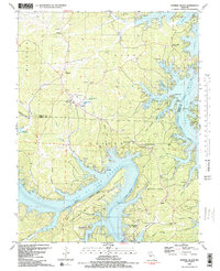
1983 Map of Sunrise Beach
USGS Topo · Published 1983About this map
Lake of the Ozarks dominates this 1980s landscape, its sprawling, branching shoreline creating a complex geography of coves and points such as Gladstone Cove, Moonlight Bay, and Galena Point. The settlements of Sunrise Beach and Laurie serve as local hubs along the ridgelines, where community life is centered around institutions like the Shrine of St Patrick and Kent Memorial Ch.
Find a feature on this map
72 named features on this map. Tap any name to fly to it.
Don’t see what you’re looking for? This feature index may not catch every label — zoom into the map to look around manually.
Map Details
Editions of this 1983 Sunrise Beach Map
2 editions found
Other maps of this area

1888 · Versailles
USGS Topo · 1:125,000

1893 · Versailles
USGS Topo · 1:125,000

1904 · Eldon
USGS Topo · 1:62,500

1904 · Gravois Mills
USGS Topo · 1:62,500

1932 · Versailles No 4
USGS Topo · 1:48,000

1934 · Camdenton
USGS Topo · 1:24,000

1934 · Purvis
USGS Topo · 1:24,000

1934 · Irontown Ferry
USGS Topo · 1:24,000

1934 · Lake Ozark
USGS Topo · 1:24,000

1934 · Green Bay Terrace
USGS Topo · 1:24,000