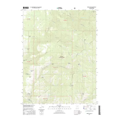
2017 Map of Sunset Peak
USGS Topo · Published 2017About this map
The Pahvant Range defines this high-elevation landscape within the Fishlake National Forest, where steep canyons and sharp ridges create a complex drainage system. Notable heights include Mine Camp Peak, Sunset Peak, and Leavitts Peak, which overlook a network of seasonal and perennial waters such as Walker Cr and Corn Creek. The map records numerous water sources essential to the region's history, including Leavitts Spring, Monk Spring, and Mortensen Spring. These features, along with names like Woolsey Ridge and Adelaide/Leavitts, point to the cattle-ranching and early pioneering history of Millard County. Extensive trails like Trail 1442 and Trail 1468 trace the terrain between landmarks like The Devils Armchair and Hell Hole Canyon, documenting the modern forest management and recreational footprint over this ancestral landscape.
Find a feature on this map
51 named features on this map. Tap any name to fly to it.
Don’t see what you’re looking for? This feature index may not catch every label — zoom into the map to look around manually.
Map Details
Editions of this 2017 Sunset Peak Map
This is the sole edition of this map. No revisions or reprints were ever made.
Other maps of this area

1885 · Beaver
USGS Topo · 1:250,000

1932 · Sevier
USGS Topo · 1:62,500

1935 · Sevier
USGS Topo · 1:62,500

1940 · Monroe
USGS Topo · 1:62,500

1944 · Monroe
USGS Topo · 1:62,500

1953 · Richfield
USGS Topo · 1:250,000

1958 · Richfield
USGS Topo · 1:250,000

1960 · Meadow
USGS Topo · 1:24,000

1961 · Fillmore
USGS Topo · 1:24,000

1961 · Mt. Catherine
USGS Topo · 1:24,000