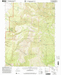
2001 Map of Sunset Peak
USGS Topo · Published 2003About this map
Fish Lake National Forest dominates this high-elevation landscape in Millard County, where steep drainages and prominent summits define the geography of the Pavant Range. Several peaks over 9,000 feet, including Mine Camp Peak and Sunset Peak, serve as focal points for a network of springs and canyons that feed the valley floor below. The presence of several prospects near Indian Spring and Sunset Canyon suggests a history of mineral exploration in these remote slopes, while an agueduct along the western edge of the forest boundary highlights the importance of water management in this arid environment.
Find a feature on this map
38 named features on this map. Tap any name to fly to it.
Don’t see what you’re looking for? This feature index may not catch every label — zoom into the map to look around manually.
Map Details
Editions of this 2001 Sunset Peak Map
This is the sole edition of this map. No revisions or reprints were ever made.
Other maps of this area

1885 · Beaver
USGS Topo · 1:250,000

1932 · Sevier
USGS Topo · 1:62,500

1935 · Sevier
USGS Topo · 1:62,500

1940 · Monroe
USGS Topo · 1:62,500

1944 · Monroe
USGS Topo · 1:62,500

1953 · Richfield
USGS Topo · 1:250,000

1958 · Richfield
USGS Topo · 1:250,000

1960 · Meadow
USGS Topo · 1:24,000

1961 · Fillmore
USGS Topo · 1:24,000

1961 · Mt. Catherine
USGS Topo · 1:24,000