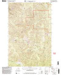
1999 Map of Sunset Peak
USGS Topo · Published 2003About this map
Sunset Peak and Sacajawea Peak anchor this high-elevation terrain within the Lolo National Forest at the close of the 1990s. The landscape is defined by the Coeur d'Alene Mountains and the prominent C C Divide, which serves as the boundary between Sanders County and Mineral County. This divide also separates the Plains Ranger District from the Superior Ranger District. The map reveals a history of extraction and mountain navigation, with several mining-related markers such as the Prospect Miller Mine and scattered prospects, adits, and a Quarry. Drainage patterns are clearly delineated, with water flowing through Eddy Creek and Swamp Creek, while isolated features like Swamp Lake provide key landmarks in the upper elevations of the Bitterroot Range foothills.
Find a feature on this map
27 named features on this map. Tap any name to fly to it.
Don’t see what you’re looking for? This feature index may not catch every label — zoom into the map to look around manually.
Map Details
Editions of this 1999 Sunset Peak Map
This is the sole edition of this map. No revisions or reprints were ever made.
Other maps of this area

1918 · St Regis
USGS Topo · 1:125,000

1919 · St. Regis
USGS Topo · 1:125,000

1937 · Thompson Falls
USGS Topo · 1:125,000

1956 · St Regis
USGS Topo · 1:62,500

1956 · Wallace
USGS Topo · 1:250,000

1959 · Plains
USGS Topo · 1:62,500

1960 · Wallace
USGS Topo · 1:250,000

1964 · Eddy Mountain
USGS Topo · 1:24,000
1964 · Big Hole Peak
USGS Topo · 1:24,000

1964 · Weeksville
USGS Topo · 1:24,000