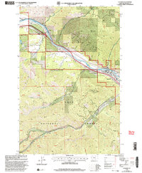
1999 Map of Superior
USGS Topo · Published 2003About this map
Superior serves as the focal point for this mountain landscape, positioned along the banks of the Clark Fork and acting as the gateway to the sprawling Lolo National Forest. The town's infrastructure includes the Superior Ranger District Office and a local Cem, while transportation and recreation routes trace the river valley, highlighted by the Dry Creek Fishing Access and Big Eddy Fishing Access. To the northwest, the small settlement of La Vista sits near the confluence of several gulches.
Find a feature on this map
35 named features on this map. Tap any name to fly to it.
Don’t see what you’re looking for? This feature index may not catch every label — zoom into the map to look around manually.
Map Details
Editions of this 1999 Superior Map
This is the sole edition of this map. No revisions or reprints were ever made.
Other maps of this area

1918 · St Regis
USGS Topo · 1:125,000

1919 · St. Regis
USGS Topo · 1:125,000

1956 · St Regis
USGS Topo · 1:62,500

1956 · Wallace
USGS Topo · 1:250,000

1957 · Illinois Peak
USGS Topo · 1:62,500

1959 · Plains
USGS Topo · 1:62,500

1960 · Wallace
USGS Topo · 1:250,000

1960 · Superior
USGS Topo · 1:62,500
1985 · Quinns Hot Springs
USGS Topo · 1:24,000
1985 · Superior
USGS Topo · 1:24,000