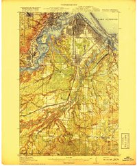
1917 Map of Superior
USGS Topo · Published 1917About this map
St Louis Bay and the interconnected waters of Lake Superior serve as the focal point for this industrial era landscape. The intricate shoreline, defined by Minnesota Point and Wisconsin Point, shelters a massive complex of rail yards and shipping facilities during a peak period of Great Lakes commerce. The rail infrastructure is dense, featuring the Northern Pacific, Great Northern, and Minneapolis St Paul and Sault Ste Marie lines converging on the port.
Find a feature on this map
81 named features on this map. Tap any name to fly to it.
Don’t see what you’re looking for? This feature index may not catch every label — zoom into the map to look around manually.
Map Details
Editions of this 1917 Superior Map
3 editions found
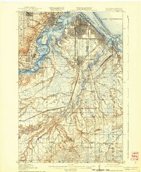
Other maps of this area

1895 · Duluth
USGS Topo · 1:62,500

1915 · Superior
USGS Topo · 1:48,000

1917 · Superior
USGS Topo · 1:62,500

1945 · Solon Springs
USGS Topo · 1:48,000

1949 · Solon Springs
USGS Topo · 1:48,000

1949 · Holyoke
USGS Topo · 1:48,000

1949 · Patzau
USGS Topo · 1:48,000

1949 · Poplar
USGS Topo · 1:48,000

1953 · Lakewood
USGS Topo · 1:24,000

1953 · Adolph
USGS Topo · 1:24,000