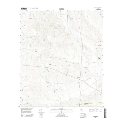
2014 Map of Surginer
USGS Topo · Published 2014About this map
Surginer and Vineland sit at the center of this rural Alabama landscape, where the border of Marengo Co and Wilcox Co cuts through a dense network of creek valleys. The terrain is defined by the winding paths of Baptizing Cr, Little Cr, and Turkey Cr, which likely shaped the early settlement patterns of the region. Many of these small communities are anchored by local cemeteries, such as the Laurel Presbyterian Cem and Christian Hope Cem, providing significant touchpoints for genealogical research.
Find a feature on this map
65 named features on this map. Tap any name to fly to it.
Don’t see what you’re looking for? This feature index may not catch every label — zoom into the map to look around manually.
Map Details
Editions of this 2014 Surginer Map
This is the sole edition of this map. No revisions or reprints were ever made.
Other maps of this area

1953 · Montgomery
USGS Topo · 1:250,000

1953 · Andalusia
USGS Topo · 1:250,000

1956 · Montgomery
USGS Topo · 1:250,000

1957 · Montgomery
USGS Topo · 1:250,000

1957 · Andalusia
USGS Topo · 1:250,000

1973 · Pine Hill
USGS Topo · 1:24,000

1973 · Thomasville
USGS Topo · 1:24,000

1978 · Surginer
USGS Topo · 1:24,000

1978 · Sweet Water
USGS Topo · 1:24,000
1978 · Bashi
USGS Topo · 1:24,000