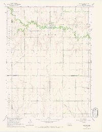
1966 Map of Surprise
USGS Topo · Published 1967About this map
The Surprise community is centered at a sharp bend in the Big Blue River during the mid-1960s, serving as a hub for the surrounding agricultural landscape of Butler and Polk counties. This survey captures a rural environment defined by the intersection of four counties, where farmsteads are connected by a grid of section lines. Evidence of earlier transportation infrastructure is visible in the Old Railroad Grade that cuts across the western portion of the map, while local landmarks like St Paul Ch and the Surprise Cem provide anchor points for genealogists researching families in Stewart and Read townships. The hydrology of the area is detailed by the winding paths of Wildcat Creek and Cottonwood Creek, which drain into the main river valley. Numerous wells are marked across the terrain, indicating the importance of groundwater for the various township districts like Hackberry.
Find a feature on this map
19 named features on this map. Tap any name to fly to it.
Don’t see what you’re looking for? This feature index may not catch every label — zoom into the map to look around manually.
Map Details
Editions of this 1966 Surprise Map
This is the sole edition of this map. No revisions or reprints were ever made.
Other maps of this area

1899 · David City
USGS Topo · 1:125,000

1934 · Seward
USGS Topo · 1:48,000

1934 · Utica
USGS Topo · 1:62,500

1937 · Utica
USGS Topo · 1:62,500

1939 · Seward
USGS Topo · 1:62,500

1955 · Fremont
USGS Topo · 1:250,000

1955 · Lincoln
USGS Topo · 1:250,000

1957 · Fremont
USGS Topo · 1:250,000

1957 · Lincoln
USGS Topo · 1:250,000

1958 · Fremont
USGS Topo · 1:250,000