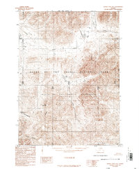
1986 Map of Survey Pass D-1
USGS Topo · Published 1986About this map
The Continental Divide cuts through this high-latitude terrain, marking the hydrological boundary where the waters of the Gates of the Arctic National Park are channeled into distinct drainage systems. Compiled from aerial photography taken in 1973, this 1986 provisional survey documents a landscape defined by significant elevations like Natal Mountain and Plateau Mountain. The map illustrates the headwaters of numerous perennial streams, including Agiak Creek and Easter Creek, which navigate the complex topography between the Gates of the Arctic Wilderness and the North Slope Borough boundary. The absence of roads or established trails highlights the preservation of this interior Alaskan region, where isolated water bodies such as Lonely Lake and Natal Lake sit among high peaks and the Kateel River Meridian.
Find a feature on this map
14 named features on this map. Tap any name to fly to it.
Don’t see what you’re looking for? This feature index may not catch every label — zoom into the map to look around manually.
Map Details
Editions of this 1986 Survey Pass D-1 Map
This is the sole edition of this map. No revisions or reprints were ever made.
Other maps of this area

1951 · Survey Pass
USGS Topo · 1:250,000

1951 · Chandler Lake
USGS Topo · 1:250,000

1951 · Killik River
USGS Topo · 1:250,000

1951 · Wiseman
USGS Topo · 1:250,000

1956 · Wiseman
USGS Topo · 1:250,000

1956 · Survey Pass
USGS Topo · 1:250,000

1956 · Chandler Lake
USGS Topo · 1:250,000

1956 · Killik River
USGS Topo · 1:250,000

1964 · Survey Pass
USGS Topo · 1:250,000

1964 · Wiseman
USGS Topo · 1:250,000