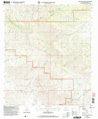
2004 Map of Surveyors Canyon
USGS Topo · Published 2006About this map
The Fort Bliss Military Reservation (McGregor Range) occupies the southern half of this landscape, marking a sharp transition between federal military territory and the protected lands of the Lincoln National Forest to the north. This 2004 revision reveals a terrain defined by complex drainage systems, where the Sacramento River and Surveyors Canyon carve through the high country. For the local historian or surveyor, the map provides a precise look at the network of livestock tanks and water catchments vital to this arid environment, including Ben Williams Tank, Kimmons Tank, and Crest Garden Tank. The presence of named landmarks like Chatfield Peak and Stevens Lake among the varied canyons of East McAfee Canyon and Wayland Canyon offers a clear view of the geographic naming conventions used by the USDA Forest Service and military cartographers at the start of the 21st century.
Find a feature on this map
20 named features on this map. Tap any name to fly to it.
Don’t see what you’re looking for? This feature index may not catch every label — zoom into the map to look around manually.
Map Details
Editions of this 2004 Surveyors Canyon Map
This is the sole edition of this map. No revisions or reprints were ever made.
Other maps of this area

1954 · Carlsbad
USGS Topo · 1:250,000

1958 · Carlsbad
USGS Topo · 1:250,000

1963 · Indian Draw
USGS Topo · 1:24,000

1965 · Bear Spring
USGS Topo · 1:24,000

1965 · Surveyors Canyon
USGS Topo · 1:24,000

1965 · Avis
USGS Topo · 1:24,000

1965 · Rogers Ruins
USGS Topo · 1:24,000

1965 · El Paso Canyon
USGS Topo · 1:24,000

1965 · Pinon
USGS Topo · 1:24,000

1979 · Alamogordo
USGS Topo · 1:100,000