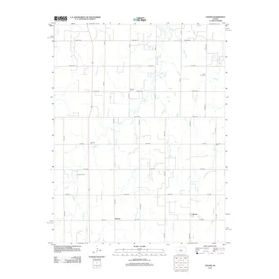
2012 Map of Susank
USGS Topo · Published 2012About this map
Susank and Stickney anchor this central Kansas landscape, where the agricultural grid is deeply established through a network of section line roads such as Winterset Rd and S Co Line Rd. The terrain is drained by several meandering waterways, including Sellens Cr and Landon Cr, which cut through the level plains. The map reveals the area's subterranean industry via the Templing Oil Field, a reminder of the region's long-standing reliance on petroleum extraction alongside farming. Local heritage is preserved in several rural burial grounds that speak to the lineage of early settlers, notably Cross Plains Cem, Michaels Cem, Schneider Cem, and Concordia Cem. These scattered landmarks provide essential points of reference for genealogists and historians tracing the families who established the small townships of Barton County.
Find a feature on this map
23 named features on this map. Tap any name to fly to it.
Don’t see what you’re looking for? This feature index may not catch every label — zoom into the map to look around manually.
Map Details
Editions of this 2012 Susank Map
This is the sole edition of this map. No revisions or reprints were ever made.
Other maps of this area

1896 · Russell
USGS Topo · 1:125,000

1955 · Great Bend
USGS Topo · 1:250,000

1956 · Dorrance SW
USGS Topo · 1:24,000

1957 · Great Bend
USGS Topo · 1:250,000

1958 · Great Bend
USGS Topo · 1:250,000

1961 · Russell SW
USGS Topo · 1:24,000

1961 · Homer
USGS Topo · 1:24,000
1969 · Olmitz
USGS Topo · 1:24,000
1969 · Beaver
USGS Topo · 1:24,000
1969 · Redwing
USGS Topo · 1:24,000