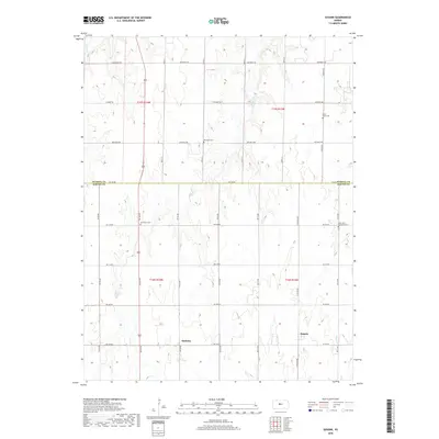
2018 Map of Susank
USGS Topo · Published 2018About this map
Susank and Stickney anchor this 2018 survey of the plains along the Russell Co Barton Co line. The landscape is defined by a rigorous section-line road grid, including Winterset Rd and Michaelis Rd, which cut across the subtle drainages of Landon Cr and Deception Cr. This modern topographic study highlights the enduring presence of local heritage sites, with several rural cemeteries scattered across the townships. Genealogists can locate Cross Plains Cem in the northeast and Saint John Lutheran Cem to the south, alongside the Michaelis Cem and Schneider Cem. The map illustrates a high-plains agricultural environment where small settlements persist amidst a network of county roads like NW 230 Rd and NE 190 Rd, reflecting the steady rural character of this Kansas region.
Find a feature on this map
28 named features on this map. Tap any name to fly to it.
Don’t see what you’re looking for? This feature index may not catch every label — zoom into the map to look around manually.
Map Details
Editions of this 2018 Susank Map
This is the sole edition of this map. No revisions or reprints were ever made.
Other maps of this area

1896 · Russell
USGS Topo · 1:125,000

1955 · Great Bend
USGS Topo · 1:250,000

1956 · Dorrance SW
USGS Topo · 1:24,000

1957 · Great Bend
USGS Topo · 1:250,000

1958 · Great Bend
USGS Topo · 1:250,000

1961 · Russell SW
USGS Topo · 1:24,000

1961 · Homer
USGS Topo · 1:24,000
1969 · Olmitz
USGS Topo · 1:24,000
1969 · Beaver
USGS Topo · 1:24,000
1969 · Redwing
USGS Topo · 1:24,000