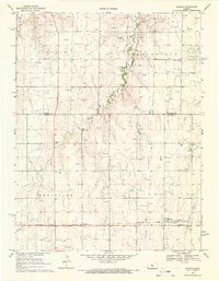
1969 Map of Susank
USGS Topo · Published 1971About this map
The Atchison Topeka and Santa Fe railroad serves as a critical axis for this Central Kansas landscape, connecting the small grain elevator stops of Susank and Stickney. In the late 1960s, the region was characterized by a dense network of oil wells that dotted the plains between drainage systems like Landon Creek and Sellens Creek. This industrial footprint is layered over a established rural social fabric evidenced by multiple local burial grounds, including Schneider Cemetery and Cross Plains Cemetery, and the Shannon Friends Church. The terrain is partitioned into local districts such as Lincoln Fairfield and Wheatland, reflecting a meticulous organization of the land for both agriculture and petroleum extraction.
Find a feature on this map
21 named features on this map. Tap any name to fly to it.
Don’t see what you’re looking for? This feature index may not catch every label — zoom into the map to look around manually.
Map Details
Editions of this 1969 Susank Map
This is the sole edition of this map. No revisions or reprints were ever made.
Other maps of this area

1896 · Russell
USGS Topo · 1:125,000

1955 · Great Bend
USGS Topo · 1:250,000

1956 · Dorrance SW
USGS Topo · 1:24,000

1957 · Great Bend
USGS Topo · 1:250,000

1958 · Great Bend
USGS Topo · 1:250,000

1961 · Russell SW
USGS Topo · 1:24,000

1961 · Homer
USGS Topo · 1:24,000
1969 · Olmitz
USGS Topo · 1:24,000
1969 · Beaver
USGS Topo · 1:24,000
1969 · Redwing
USGS Topo · 1:24,000