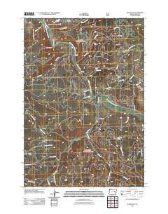
2011 Map of Susanville
USGS Topo · Published 2011About this map
The Middle Fork John Day River carves through this mountainous corner of Grant County, defining a landscape shaped by mining and high-elevation ranching. The small settlement of Galena serves as a central point near the Galena Cemetery, while Susanville sits further east along Elk Creek. This map documents a region where industry and geography are closely tied, shown through the presence of the Gem Mine near Gem Meadows and the high vantage of Crockett Knob Lookout to the southeast. Transport in the early 21st century relied on routes like Susanville Rd and Up Middle Fork Rd, which follow the natural contours of Cole Canyon and Buck Gulch. From the quiet waters of Balance Lake to the broad expanse of Beymer Flat, the map captures the remote character of the Blue Mountains, where family names are preserved on landmarks such as O'Rorke Ranch.
Find a feature on this map
45 named features on this map. Tap any name to fly to it.
Don’t see what you’re looking for? This feature index may not catch every label — zoom into the map to look around manually.
Map Details
Editions of this 2011 Susanville Map
This is the sole edition of this map. No revisions or reprints were ever made.
Other maps of this area

1949 · Susanville
USGS Topo · 1:62,500

1951 · Susanville
USGS Topo · 1:62,500

1951 · Dale
USGS Topo · 1:62,500

1951 · Bates
USGS Topo · 1:62,500

1951 · Desolation Butte
USGS Topo · 1:62,500

1955 · Canyon City
USGS Topo · 1:250,000

1959 · Canyon City
USGS Topo · 1:250,000
1987 · Bates
USGS Topo · 1:100,000
1988 · Desolation Butte
USGS Topo · 1:24,000
1988 · Boulder Butte
USGS Topo · 1:24,000