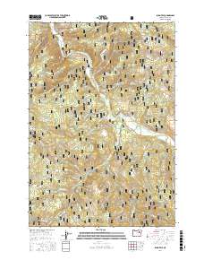
2017 Map of Susanville
USGS Topo · Published 2017About this map
Galena and the nearby settlement of Susanville sit in the northern reaches of the Malheur National Forest, where the terrain is defined by the winding course of the Middle Fork John Day River. This interior Oregon landscape is marked by deep canyons and gulches, including Cole Canyon and Buck Gulch, which drain into the river system. The presence of the Galena Cem and named flats like Whisky Flat suggests the historical footprint of earlier mining and ranching activities that once dominated this remote section of Grant County.
Find a feature on this map
60 named features on this map. Tap any name to fly to it.
Don’t see what you’re looking for? This feature index may not catch every label — zoom into the map to look around manually.
Map Details
Editions of this 2017 Susanville Map
This is the sole edition of this map. No revisions or reprints were ever made.
Other maps of this area

1949 · Susanville
USGS Topo · 1:62,500

1951 · Susanville
USGS Topo · 1:62,500

1951 · Dale
USGS Topo · 1:62,500

1951 · Bates
USGS Topo · 1:62,500

1951 · Desolation Butte
USGS Topo · 1:62,500

1955 · Canyon City
USGS Topo · 1:250,000

1959 · Canyon City
USGS Topo · 1:250,000
1987 · Bates
USGS Topo · 1:100,000
1988 · Desolation Butte
USGS Topo · 1:24,000
1988 · Boulder Butte
USGS Topo · 1:24,000