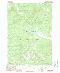
1990 Map of Susanville
USGS Topo · Published 1990About this map
Susanville and the nearby site of Galena anchor this survey of the Malheur National Forest in eastern Oregon. Situated along the Middle Fork of the John Day River, this area is defined by its history of mining and remote settlement within the Blue Mountains. The landscape is characterized by steep drainages like Armstrong Creek and high-elevation clearings such as Gibbs Meadow. These features reflect a legacy of resource extraction and seasonal grazing that shaped the development of Grant County. The map provides a clear look at the network of Forest Service roads and trails that connected these isolated outposts to the larger region during the late twentieth century, capturing the transition from early pioneer mining camps to a landscape primarily managed for public forest land and conservation.
Find a feature on this map
4 named features on this map. Tap any name to fly to it.
Don’t see what you’re looking for? This feature index may not catch every label — zoom into the map to look around manually.
Map Details
Editions of this 1990 Susanville Map
This is the sole edition of this map. No revisions or reprints were ever made.
Other maps of this area

1949 · Susanville
USGS Topo · 1:62,500

1951 · Susanville
USGS Topo · 1:62,500

1951 · Dale
USGS Topo · 1:62,500

1951 · Bates
USGS Topo · 1:62,500

1951 · Desolation Butte
USGS Topo · 1:62,500

1955 · Canyon City
USGS Topo · 1:250,000

1959 · Canyon City
USGS Topo · 1:250,000
1987 · Bates
USGS Topo · 1:100,000
1988 · Desolation Butte
USGS Topo · 1:24,000
1988 · Boulder Butte
USGS Topo · 1:24,000