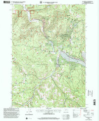
1999 Map of Susanville
USGS Topo · Published 2002About this map
Susanville and Galena anchor this detailed study of the Malheur National Forest as it appeared in the late twentieth century. Located along the winding Middle Fork John Day River, these small settlements are surrounded by evidence of decades of resource extraction, with numerous Mine Shafts, a Quarry, and individual Mine sites peppering the drainages of Quartz Gulch and Deep Gulch. A small Cem near Susanville serves as a vital marker for genealogists tracing families in this remote corner of Grant County.
Find a feature on this map
49 named features on this map. Tap any name to fly to it.
Don’t see what you’re looking for? This feature index may not catch every label — zoom into the map to look around manually.
Map Details
Editions of this 1999 Susanville Map
This is the sole edition of this map. No revisions or reprints were ever made.
Other maps of this area

1949 · Susanville
USGS Topo · 1:62,500

1951 · Susanville
USGS Topo · 1:62,500

1951 · Dale
USGS Topo · 1:62,500

1951 · Bates
USGS Topo · 1:62,500

1951 · Desolation Butte
USGS Topo · 1:62,500

1955 · Canyon City
USGS Topo · 1:250,000

1959 · Canyon City
USGS Topo · 1:250,000
1987 · Bates
USGS Topo · 1:100,000
1988 · Desolation Butte
USGS Topo · 1:24,000
1988 · Boulder Butte
USGS Topo · 1:24,000