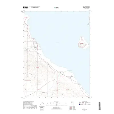
2018 Map of Sutcliffe
USGS Topo · Published 2018About this map
Pyramid Lake dominates the eastern half of this terrain, defining the shoreline and island geography of this portion of Washoe County. The map details the western bank, where the residential footprint of the community is organized along roads like Sutcliffe Dr and Lakeview Dr, stretching toward the waters of Tamarack Bay. Significant geological and hydrologic features are noted offshore, including the sanctuary of Anaho Island with its Anaho Island Spring and the distinctive formation of The Pyramid near the northeastern corner. Inland, the landscape rises toward Jackass Peak, cut by deep drainages such as Hardscrabble Canyon and Quail Canyon. These landmarks, along with coastal points like Pelican Point and Lombardo Point, reflect a landscape shaped by both the high desert environment and its prominent terminal lake.
Find a feature on this map
29 named features on this map. Tap any name to fly to it.
Don’t see what you’re looking for? This feature index may not catch every label — zoom into the map to look around manually.
Map Details
Editions of this 2018 Sutcliffe Map
This is the sole edition of this map. No revisions or reprints were ever made.
Other maps of this area

1886 · Granite Range
USGS Topo · 1:250,000

1890 · Wadsworth
USGS Topo · 1:125,000

1891 · Reno
USGS Topo · 1:125,000

1892 · Wadsworth
USGS Topo · 1:125,000

1893 · Reno
USGS Topo · 1:125,000

1894 · Granite Range
USGS Topo · 1:250,000

1894 · Wadsworth
USGS Topo · 1:125,000

1955 · Lovelock
USGS Topo · 1:250,000

1957 · Sutcliffe
USGS Topo · 1:62,500

1957 · Nixon
USGS Topo · 1:62,500