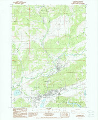
1988 Map of Sutherlin
USGS Topo · Published 1988About this map
Oakland and Sutherlin anchor this mid-1980s landscape, where the Southern Pacific railroad follows the winding path of Calapooya Creek. The geography reveals a transition from the historic center at Old Town to the modern municipal developments of the late 20th century. Notable landmarks include the Rochester Covered Bridge and the Sutherlin Municipal Airport, alongside recreational and industrial sites like the Golf Course and several active quarries.
Find a feature on this map
40 named features on this map. Tap any name to fly to it.
Don’t see what you’re looking for? This feature index may not catch every label — zoom into the map to look around manually.
Map Details
Editions of this 1988 Sutherlin Map
This is the sole edition of this map. No revisions or reprints were ever made.
Other maps of this area

1897 · Roseburg
USGS Topo · 1:125,000

1900 · Roseburg
USGS Topo · 1:125,000

1954 · Sutherlin
USGS Topo · 1:62,500

1954 · Drain
USGS Topo · 1:62,500

1954 · Anlauf
USGS Topo · 1:62,500

1954 · Glide
USGS Topo · 1:62,500

1958 · Roseburg
USGS Topo · 1:250,000

1959 · Roseburg
USGS Topo · 1:250,000

1979 · Roseburg
USGS Topo · 1:100,000

1979 · Cottage Grove
USGS Topo · 1:100,000