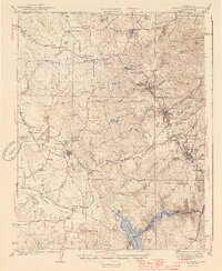
1944 Map of Sutter Creek
USGS Topo · Published 1944About this map
Preston School of Industry dominates the central landscape near Ione, reflecting the institutional history of Amador County during the mid-1940s. The region is a dense network of gold-rush era settlements and resource infrastructure, where the Amador Canal snakes through the foothills to serve towns like Sutter Creek and Amador City. The survey captures the industrial footprint of the Mother Lode, from the Southern Pacific rail lines terminating at Martell to the numerous gulches and hills like Irish Hill and Quartz Mtn that defined the local mining economy. To the south, the Mokelumne River is partially contained by the Pardee Reservoir, marking the boundary with Calaveras County. Smaller agricultural outposts and schools, such as Willow Springs Sch and Jackson Valley Sch, provide essential touchpoints for genealogists tracing family locations between the larger hubs of Jackson and Plymouth.
Find a feature on this map
78 named features on this map. Tap any name to fly to it.
Don’t see what you’re looking for? This feature index may not catch every label — zoom into the map to look around manually.
Map Details
Editions of this 1944 Sutter Creek Map
2 editions found

Other maps of this area

1889 · Jackson
USGS Topo · 1:125,000

1891 · Sacramento
USGS Topo · 1:125,000

1891 · Placerville
USGS Topo · 1:125,000

1892 · Jackson
USGS Topo · 1:125,000

1892 · Sacramento
USGS Topo · 1:125,000

1892 · Placerville
USGS Topo · 1:125,000

1893 · Placerville
USGS Topo · 1:125,000

1893 · Sacramento
USGS Topo · 1:125,000

1894 · Lodi
USGS Topo · 1:125,000

1897 · Jackson
USGS Topo · 1:125,000