
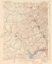
1944 Map of Sutter Creek
USGS Topo · Published 1944About this map
Sutter Creek and Jackson anchor this mid-century survey of the Mother Lode region, capturing the landscape during the Second World War. The terrain is defined by a complex network of waterways and mining-era infrastructure, including the Sutter Canal and Amador Canal. Local industry and institutional history are visible through the Preston School of Industry near Ione and the extensive workings at Amador City and Drytown. The Southern Pacific railroad serves the western valley, while the rugged eastern uplands are marked by numerous gulches such as Gopher Gulch and Whisky Gulch. To the south, the Mokelumne River flows into the Pardee Reservoir, illustrating the mid-century water management systems that transformed the local geography. This document provides a clear view of the transition between the agricultural Ione Valley and the storied mining districts of the Sierra foothills.
Find a feature on this map
75 named features on this map. Tap any name to fly to it.
Don’t see what you’re looking for? This feature index may not catch every label — zoom into the map to look around manually.
Map Details
Editions of this 1944 Sutter Creek Map
2 editions found
Other maps of this area

1889 · Jackson
USGS Topo · 1:125,000

1891 · Sacramento
USGS Topo · 1:125,000

1891 · Placerville
USGS Topo · 1:125,000

1892 · Jackson
USGS Topo · 1:125,000

1892 · Sacramento
USGS Topo · 1:125,000

1892 · Placerville
USGS Topo · 1:125,000

1893 · Placerville
USGS Topo · 1:125,000

1893 · Sacramento
USGS Topo · 1:125,000

1894 · Lodi
USGS Topo · 1:125,000

1897 · Jackson
USGS Topo · 1:125,000