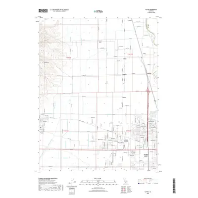
2018 Map of Sutter
USGS Topo · Published 2018About this map
The prominent volcanic formations of the Sutter Buttes rise sharply in the northwest, casting a shadow over the agricultural landscape of the Sacramento Valley. This region is defined by a dense network of irrigation and drainage infrastructure, including the Wadsworth Canal, Live Oak Canal, and the Sutter County Extension Canal, which support the intensive cultivation surrounding the town of Sutter. To the east, the Feather River serves as a natural boundary between Sutter Co and Yuba Co, as the landscape transitions into the residential expansion of Yuba City. The map reveals a tapestry of small settlements such as Encinal, Nuestro, and Tierra Buena, interspersed with local landmarks like the Sutter Butte Dusters Airport and Sutter Cem. This layout illustrates the area's dual character as both a productive farming heartland and a growing suburban corridor anchored by the nearby college and transit nodes like Colusa Junction.
Find a feature on this map
52 named features on this map. Tap any name to fly to it.
Don’t see what you’re looking for? This feature index may not catch every label — zoom into the map to look around manually.
Map Details
Editions of this 2018 Sutter Map
This is the sole edition of this map. No revisions or reprints were ever made.
Other maps of this area

1888 · Marysville
USGS Topo · 1:125,000

1891 · Marysville
USGS Topo · 1:125,000

1894 · Marysville
USGS Topo · 1:125,000

1895 · Marysville
USGS Topo · 1:125,000

1911 · Sutter
USGS Topo · 1:31,680
1911 · Yuba City
USGS Topo · 1:31,680

1911 · Gilsizer Slough
USGS Topo · 1:31,680
1911 · Ostrom
USGS Topo · 1:31,680

1912 · Marysville Buttes
USGS Topo · 1:31,680

1912 · Pennington
USGS Topo · 1:31,680