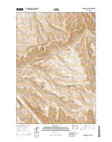
2014 Map of Swaggart Buttes
USGS Topo · Published 2014About this map
Swaggart Buttes rises above a deeply etched landscape of high-desert drainage systems in eastern Oregon. This 2014 survey reveals a region defined by its rugged hydrology, where the seasonal flows of Sourdough Cr and Willow Cr navigate through significant geological features like Blackhorse Canyon and Strawberry Canyon. The map preserves the names of early water management and natural landmarks, including Turner Reservoir and Munkers Spring, which likely served as vital resources for local ranching operations.
Find a feature on this map
26 named features on this map. Tap any name to fly to it.
Don’t see what you’re looking for? This feature index may not catch every label — zoom into the map to look around manually.
Map Details
Editions of this 2014 Swaggart Buttes Map
This is the sole edition of this map. No revisions or reprints were ever made.
Other maps of this area

1906 · Blalock Island
USGS Topo · 1:125,000

1908 · Blalock Island
USGS Topo · 1:125,000

1908 · Umatilla
USGS Topo · 1:125,000

1953 · Pendleton
USGS Topo · 1:250,000

1956 · Pendleton
USGS Topo · 1:250,000

1968 · Swaggart Buttes
USGS Topo · 1:24,000

1968 · Lexington
USGS Topo · 1:24,000

1968 · Ruggs
USGS Topo · 1:24,000

1968 · Gleason Butte
USGS Topo · 1:24,000

1968 · Butter Creek Junction
USGS Topo · 1:24,000