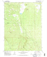
1979 Map of Swain Mountain
USGS Topo · Published 1995About this map
Lassen National Forest terrain dominates this high-country landscape, where the volcanic topography of the southern Cascades creates a complex network of meadows and seasonal drainages. The Susan River originates in the northern section of the sheet, winding through Clover Valley before reaching Lake Norvell at Norvell Flat. This area serves as a critical hydrological junction, where waters flow toward both the Great Basin and the Sacramento River watershed. Significant landmarks like Swain Mountain and Jennie Mtn rise above the timbered flats, providing prominent reference points for early travelers. The historic Lassen Trail cuts across the northeastern corner, tracing a path used by mid-century emigrants. Land use is evidenced by the Cinder Pit near Clover Butte and the winding Silver Lake Road, reflecting the region's history of logging and resource management within the forest boundaries at the Lassen and Plumas county line.
Find a feature on this map
26 named features on this map. Tap any name to fly to it.
Don’t see what you’re looking for? This feature index may not catch every label — zoom into the map to look around manually.
Map Details
Editions of this 1979 Swain Mountain Map
2 editions found
Other maps of this area

1886 · Honey Lake
USGS Topo · 1:250,000

1886 · Lassen Peak
USGS Topo · 1:250,000

1891 · Honey Lake
USGS Topo · 1:250,000

1892 · Lassen Peak
USGS Topo · 1:250,000

1893 · Honey Lake
USGS Topo · 1:250,000

1894 · Lassen Peak
USGS Topo · 1:250,000

1939 · Halls Flat
USGS Topo · 1:125,000

1955 · Westwood
USGS Topo · 1:62,500

1955 · Westwood
USGS Topo · 1:250,000

1956 · Chester
USGS Topo · 1:62,500