
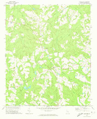
1971 Map of Swainsboro
USGS Topo · Published 1973About this map
Swainsboro serves as a radiating hub of activity in the early 1970s, defined by its cross-shaped grid of major streets and the Central of Georgia rail line. The landscape surrounding the city is a blend of recreational and utility features, from the Swainsboro Speedway and Drive-in Theater in the north to the Yam Grandy State Park and its accompanying Golf Course to the west. Evidence of the region's aviation and social infrastructure is clear, with the Emanuel County Airport and the Daniels Landing Strip providing air access, while several country churches like Bethel Ch and Mt Shady Ch anchor the rural outskirts.
Find a feature on this map
70 named features on this map. Tap any name to fly to it.
Don’t see what you’re looking for? This feature index may not catch every label — zoom into the map to look around manually.
Map Details
Editions of this 1971 Swainsboro Map
This is the sole edition of this map. No revisions or reprints were ever made.
Other maps of this area

1957 · Macon
USGS Topo · 1:250,000

1958 · Macon
USGS Topo · 1:250,000

1964 · Macon
USGS Topo · 1:250,000

1970 · Covena
USGS Topo · 1:24,000

1970 · Nunez
USGS Topo · 1:24,000

1971 · Norristown
USGS Topo · 1:24,000

1971 · Stillmore
USGS Topo · 1:24,000

1971 · Dellwood
USGS Topo · 1:24,000

1971 · Twin City
USGS Topo · 1:24,000
1971 · Canoochee
USGS Topo · 1:24,000