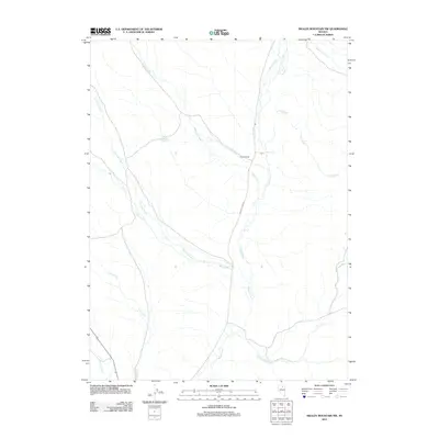
2012 Map of Swales Mountain NW
USGS Topo · Published 2012About this map
Coyote Ranch sits as a lonely outpost in this drainage-rich portion of Elko County, where the high desert is defined by an intricate network of waterways. The U.S. Geological Survey documents a landscape dominated by the winding path of Maggie Creek, which is paralleled by the unpaved Maggie Creek Rd. This area serves as a critical watershed, with numerous tributaries such as Jack Creek, Little Jack Creek, and Coyote Creek converging through the basin. The presence of Chicken Springs and various named creeks like Fish Creek and Spring Creek indicates the essential role of water in this ranching and grazing environment. The lack of concentrated development emphasizes the ranch-based economy of the region, where roads are few and land use is tied directly to the seasonal flow of mountain-fed streams.
Find a feature on this map
13 named features on this map. Tap any name to fly to it.
Don’t see what you’re looking for? This feature index may not catch every label — zoom into the map to look around manually.
Map Details
Editions of this 2012 Swales Mountain NW Map
This is the sole edition of this map. No revisions or reprints were ever made.
Other maps of this area

1955 · McDermitt
USGS Topo · 1:250,000

1955 · Winnemucca
USGS Topo · 1:250,000

1958 · Winnemucca
USGS Topo · 1:250,000

1958 · Blue Basin
USGS Topo · 1:24,000

1958 · Huntsman Ranch
USGS Topo · 1:24,000
1958 · Swales Mountain
USGS Topo · 1:24,000

1959 · McDermitt
USGS Topo · 1:250,000

1962 · Winnemucca
USGS Topo · 1:250,000

1968 · Rodeo Creek NE
USGS Topo · 1:24,000

1968 · Welches Canyon
USGS Topo · 1:24,000