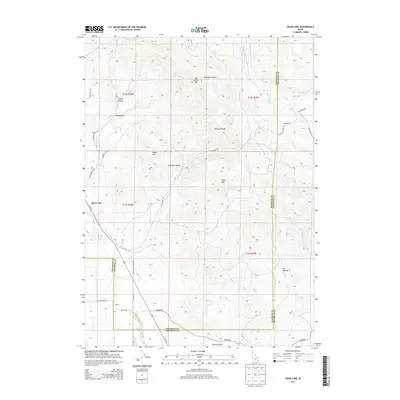
2013 Map of Swan Lake
USGS Topo · Published 2013About this map
Swan Lake sits at the base of the Portneuf Range along the border of Bannock and Franklin counties, marking a significant hydrologic and transit corridor. The terrain is defined by dramatic elevation shifts, from the high peaks of Dry Hollow Mtn and Heart Mtn down through Hutchins Canyon to the valley floor. Irrigation infrastructure, including the Treasureton Canal, snakes across the eastern slopes, supporting the agricultural life of the region. The map details the scattered settlement patterns near Coulam and the open expanses of Poverty Flats to the south. Historically significant transport routes like Us 91 N and the surrounding network of local connectors like Stockton Rd follow the natural contours of the land, linking these small communities through the rugged Idaho landscape. Natural water features such as Swan Lake Slough and various mountain springs like Heart Mountain Spring provide essential water sources in this high-altitude environment.
Find a feature on this map
40 named features on this map. Tap any name to fly to it.
Don’t see what you’re looking for? This feature index may not catch every label — zoom into the map to look around manually.
Map Details
Editions of this 2013 Swan Lake Map
This is the sole edition of this map. No revisions or reprints were ever made.
Other maps of this area

1915 · Preston
USGS Topo · 1:96,000

1918 · Preston
USGS Topo · 1:125,000

1954 · Pocatello
USGS Topo · 1:250,000

1955 · Preston
USGS Topo · 1:250,000

1958 · Pocatello
USGS Topo · 1:250,000

1958 · Preston
USGS Topo · 1:250,000

1962 · Preston
USGS Topo · 1:250,000

1968 · Oxford
USGS Topo · 1:24,000

1968 · Clifton
USGS Topo · 1:24,000
1968 · Downey East
USGS Topo · 1:24,000