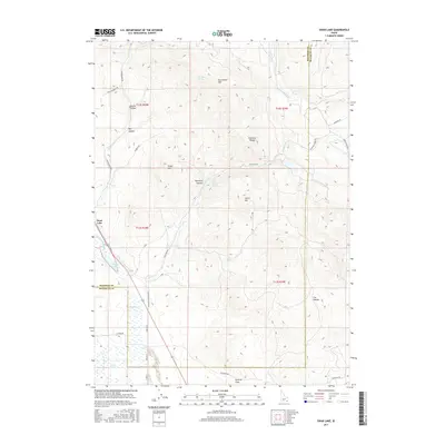
2017 Map of Swan Lake
USGS Topo · Published 2017About this map
The Swan Lake settlement lies at the boundary of the Portneuf Range, marking a point of transition between the high peaks and the marshy lowlands of the south. This 2017 survey shows the intricate hydraulic network required to manage water in this high-altitude environment, featuring the Treasureton Canal and various named sources such as Dry Hollow Spring and Heart Mountain Spring. The southern portion of the quadrangle is defined by the significant wetland areas of Swan Lake Slough and Oxford Slough, which dominate the geography near Poverty Flats. Higher elevations are punctuated by family-named and topographic landmarks like Cedar Hill, Heart Mtn, and Dry Hollow Mtn. The road network, including Stockton Rd and Cottonwood Rd, follows the natural contours of the canyons and ridgelines, illustrating the persistent influence of the terrain on local movement and ranching access.
Find a feature on this map
39 named features on this map. Tap any name to fly to it.
Don’t see what you’re looking for? This feature index may not catch every label — zoom into the map to look around manually.
Map Details
Editions of this 2017 Swan Lake Map
This is the sole edition of this map. No revisions or reprints were ever made.
Other maps of this area

1915 · Preston
USGS Topo · 1:96,000

1918 · Preston
USGS Topo · 1:125,000

1954 · Pocatello
USGS Topo · 1:250,000

1955 · Preston
USGS Topo · 1:250,000

1958 · Pocatello
USGS Topo · 1:250,000

1958 · Preston
USGS Topo · 1:250,000

1962 · Preston
USGS Topo · 1:250,000

1968 · Oxford
USGS Topo · 1:24,000

1968 · Clifton
USGS Topo · 1:24,000
1968 · Downey East
USGS Topo · 1:24,000