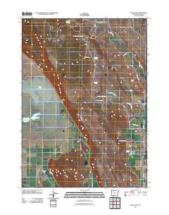
2011 Map of Swan Lake
USGS Topo · Published 2011About this map
Swan Lake dominates the western portion of this high-desert basin in Klamath County, Oregon. The landscape is defined by its water management and ranching history, with numerous vital water sources like Rattlesnake Spring and Jack-Frost Spring scattered throughout the drainage systems. The presence of Horton Dam and reservoirs such as Chapman Reservoir illustrate the infrastructure required to sustain the Swan Lake Valley ranching operations.
Find a feature on this map
24 named features on this map. Tap any name to fly to it.
Don’t see what you’re looking for? This feature index may not catch every label — zoom into the map to look around manually.
Map Details
Editions of this 2011 Swan Lake Map
This is the sole edition of this map. No revisions or reprints were ever made.
Other maps of this area

1889 · Klamath
USGS Topo · 1:250,000

1894 · Klamath
USGS Topo · 1:250,000

1955 · Klamath Falls
USGS Topo · 1:250,000

1957 · Merrill
USGS Topo · 1:62,500

1957 · Swan Lake
USGS Topo · 1:62,500

1957 · Malin
USGS Topo · 1:62,500

1958 · Klamath Falls
USGS Topo · 1:250,000

1960 · Beatty
USGS Topo · 1:62,500

1975 · Merrill NW
USGS Topo · 1:24,000
1985 · Dairy
USGS Topo · 1:24,000