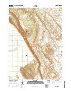
2014 Map of Swan Lake
USGS Topo · Published 2014About this map
Swan Lake Rim dominates the western topography of this Klamath County region, overlooking the expansive Swan Lake Valley and the seasonal waters of Swan Lake. The landscape is a complex network of hydrologic features and agricultural ranching infrastructure, characterized by numerous named springs such as Applegate Spring, First Sheep Camp Spring, and Jack Frost Spring. These water sources feed into various reservoirs including the C C Porter Reservoir and Parker Reservoir, which support the livestock and land management of the high desert terrain. In the southeast, the OC&E Woods Line State Trl follows a historical rail corridor, providing a clear artifact of the area's transportation history as it skirts the Yonna Valley. The distribution of these features highlights the ongoing importance of water rights and mountain-to-basin drainage in the eastern Cascades foothills.
Find a feature on this map
37 named features on this map. Tap any name to fly to it.
Don’t see what you’re looking for? This feature index may not catch every label — zoom into the map to look around manually.
Map Details
Editions of this 2014 Swan Lake Map
This is the sole edition of this map. No revisions or reprints were ever made.
Other maps of this area

1889 · Klamath
USGS Topo · 1:250,000

1894 · Klamath
USGS Topo · 1:250,000

1955 · Klamath Falls
USGS Topo · 1:250,000

1957 · Merrill
USGS Topo · 1:62,500

1957 · Swan Lake
USGS Topo · 1:62,500

1957 · Malin
USGS Topo · 1:62,500

1958 · Klamath Falls
USGS Topo · 1:250,000

1960 · Beatty
USGS Topo · 1:62,500

1975 · Merrill NW
USGS Topo · 1:24,000
1985 · Dairy
USGS Topo · 1:24,000