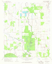
1967 Map of Swan Lake NW
USGS Topo · Published 1968About this map
Leroy Percy State Park and the Yazoo National Wildlife Refuge anchor this mid-century survey of the Mississippi Delta. The landscape is defined by the intricate meanders of Black Bayou, Granicus Bayou, and Puzzle Bayou, which carve through a region dominated by agricultural flumes and scattered rural settlements. Cultural landmarks like the Indian Mounds near the Illinois Central railroad line provide a link to the deep history of Washington County, while the presence of Macedonia Cem, Mt Tabor Ch, and Strangers Home Ch reflects the established community networks of the 1960s. The map illustrates a transitional period for the Delta, where traditional rail-and-river transport exists alongside a modern Landing Strip, and water management features like Gamble Lake and Brushy Lake illustrate the ongoing engineering of the local wetlands.
Find a feature on this map
20 named features on this map. Tap any name to fly to it.
Don’t see what you’re looking for? This feature index may not catch every label — zoom into the map to look around manually.
Map Details
Editions of this 1967 Swan Lake NW Map
This is the sole edition of this map. No revisions or reprints were ever made.
Other maps of this area

1939 · Readland
USGS Topo · 1:62,500

1939 · Refuge
USGS Topo · 1:62,500

1939 · Tralake
USGS Topo · 1:62,500

1939 · Swan Lake
USGS Topo · 1:62,500

1953 · Greenwood
USGS Topo · 1:250,000

1956 · Greenwood
USGS Topo · 1:250,000
1967 · Tribbett
USGS Topo · 1:24,000

1967 · Arcola
USGS Topo · 1:24,000
1967 · Percy
USGS Topo · 1:24,000
1968 · Hollandale
USGS Topo · 1:24,000