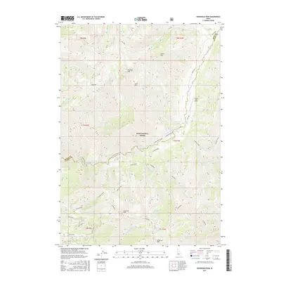
2017 Map of Swanholm Peak
USGS Topo · Published 2017About this map
The Boise National Forest dominates this Idaho landscape, where the North Fork Boise River cuts a deep path through the high peaks of Boise and Elmore Counties. The 2017 survey reveals a wilderness managed for both natural resources and recreational access, anchored by the Swanholm Lookout atop Swanholm Peak. This high-altitude vantage point overlooks a complex drainage system fed by Big Silver Cr, Graham Cr, and Lodgepole Cr. Small high-mountain basins hold isolated water bodies like Blue Jay Lake and Warrior Lakes, while the presence of the Graham USFS Airport and local labels such as Dead Elk and Bayhouse reflect the specialized needs of forest service operations and backcountry navigation. The map provides a detailed view of the roadless character of the region, emphasizing the primary river corridor and the high ridges of Goat Mtn and Shephard Peak.
Find a feature on this map
49 named features on this map. Tap any name to fly to it.
Don’t see what you’re looking for? This feature index may not catch every label — zoom into the map to look around manually.
Map Details
Editions of this 2017 Swanholm Peak Map
This is the sole edition of this map. No revisions or reprints were ever made.
Other maps of this area

1891 · Bear Valley
USGS Topo · 1:125,000

1893 · Bear Valley
USGS Topo · 1:125,000

1894 · Rocky Bar
USGS Topo · 1:125,000

1955 · Hailey
USGS Topo · 1:250,000

1957 · Challis
USGS Topo · 1:250,000

1959 · Hailey
USGS Topo · 1:250,000

1960 · Challis
USGS Topo · 1:250,000

1962 · Hailey
USGS Topo · 1:250,000

1963 · Challis
USGS Topo · 1:250,000
1972 · Bear River
USGS Topo · 1:24,000