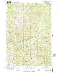
1972 Map of Swanholm Peak
USGS Topo · Published 1976About this map
Graham (Site) and the nearby Graham Mill (Site) occupy a remote clearing along the North Fork Boise River, illustrating the high-elevation mining and milling operations once active in this portion of the Boise National Forest. The landscape is dominated by steep summits such as Swanholm Peak and Graham Peak, with an intricate drainage network including Silver Creek and Johnson Creek. By the early 1970s, the area had transitioned toward remote forest management and recreation, evidenced by the Graham Guard Sta, the Graham Landing Strip, and multiple campgrounds. A network of Pack Trails and Jeep Trails provides the only access through the rugged terrain, crossing the Boise and Elmore County line. Isolated mining Prospects remain scattered across the slopes, marking the legacy of mineral exploration near Silver Mountain.
Find a feature on this map
47 named features on this map. Tap any name to fly to it.
Don’t see what you’re looking for? This feature index may not catch every label — zoom into the map to look around manually.
Map Details
Editions of this 1972 Swanholm Peak Map
This is the sole edition of this map. No revisions or reprints were ever made.
Other maps of this area

1891 · Bear Valley
USGS Topo · 1:125,000

1893 · Bear Valley
USGS Topo · 1:125,000

1894 · Rocky Bar
USGS Topo · 1:125,000

1955 · Hailey
USGS Topo · 1:250,000

1957 · Challis
USGS Topo · 1:250,000

1959 · Hailey
USGS Topo · 1:250,000

1960 · Challis
USGS Topo · 1:250,000

1962 · Hailey
USGS Topo · 1:250,000

1963 · Challis
USGS Topo · 1:250,000
1972 · Bear River
USGS Topo · 1:24,000