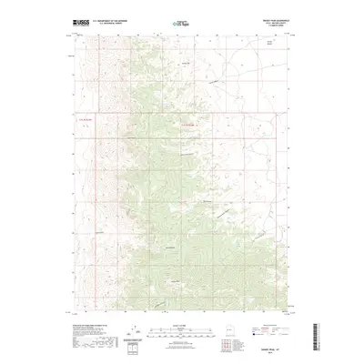
2023 Map of Swasey Peak
USGS Topo · Published 2023About this map
Swasey Peak and the high ridges of Swasey Mtn dominate this Millard County landscape, where the House Range reveals a complex system of drainage and high-altitude basins. The map captures a topography defined by steep relief and secluded pockets like Sawmill Basin and Sawmill Basin Canyon, which suggest historical wood-cutting activity in an otherwise arid environment. Water sources are critical here, with numerous named points such as Robbers Roost Spring, Chokecherry Spring, and Sinbad Spring providing life in the deep folds of Robbers Roost Canyon and Sinbad Canyon. The transition from the high peaks to the flat expanse of Swasey Bottom in the northeast illustrates the dramatic basin-and-range geology. Modern access is primarily limited to the Swasey Spring Rd, leaving landmarks like Tatow Knob and Box Canyon as remote points of interest for those studying the physical geography of the Great Basin.
Find a feature on this map
23 named features on this map. Tap any name to fly to it.
Don’t see what you’re looking for? This feature index may not catch every label — zoom into the map to look around manually.
Map Details
Editions of this 2023 Swasey Peak Map
This is the sole edition of this map. No revisions or reprints were ever made.
Other maps of this area

1908 · Fish Springs
USGS Topo · 1:250,000

1910 · Fish Springs
USGS Topo · 1:250,000

1953 · Topaz Mtn
USGS Topo · 1:62,500

1953 · Delta
USGS Topo · 1:250,000

1958 · Delta
USGS Topo · 1:250,000

1962 · Delta
USGS Topo · 1:250,000

1967 · Sand Pass
USGS Topo · 1:24,000

1967 · Sand Pass SE
USGS Topo · 1:24,000

1972 · Whirlwind Valley SW
USGS Topo · 1:24,000

1972 · Swasey Peak SW
USGS Topo · 1:24,000