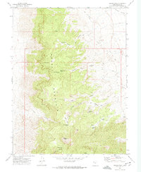
1972 Map of Swasey Peak
USGS Topo · Published 1974About this map
Swasey Mountain dominates this portion of the House Range, where a network of springs provided essential water for high-desert survival and movement. The geography here is marked by deep cuts such as Box Canyon and Sinbad Canyon, leading down from the prominent Swasey Peak. One of the most intriguing historical sites is the Robbers Roost (Cave) and its associated Robbers Roost Spring, suggesting the area's utility as a secluded refuge. The presence of Prospects in the northeast and a Corral near Swasey Bottom indicates a landscape used for both small-scale mining and livestock management. This 1970s survey captures a moment when the rugged interior was accessible only by a Pack Trail or Jeep Trail, preserving the character of a frontier environment before more modern development.
Find a feature on this map
27 named features on this map. Tap any name to fly to it.
Don’t see what you’re looking for? This feature index may not catch every label — zoom into the map to look around manually.
Map Details
Editions of this 1972 Swasey Peak Map
This is the sole edition of this map. No revisions or reprints were ever made.
Other maps of this area

1908 · Fish Springs
USGS Topo · 1:250,000

1910 · Fish Springs
USGS Topo · 1:250,000

1953 · Topaz Mtn
USGS Topo · 1:62,500

1953 · Delta
USGS Topo · 1:250,000

1958 · Delta
USGS Topo · 1:250,000

1962 · Delta
USGS Topo · 1:250,000

1967 · Sand Pass
USGS Topo · 1:24,000

1967 · Sand Pass SE
USGS Topo · 1:24,000

1972 · Whirlwind Valley SW
USGS Topo · 1:24,000

1972 · Swasey Peak SW
USGS Topo · 1:24,000