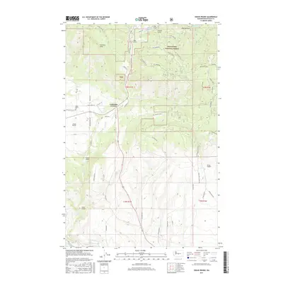
2017 Map of Swauk Prairie
USGS Topo · Published 2017About this map
Swauk Prairie occupies a distinct geological bench in the Kittitas Valley, where open grasslands meet the rising slopes of the Wenatchee National Forest. This 2017 survey details the complex interface of irrigation and natural drainage, with the North Branch Canal cutting across the southern terrain while the Teanaway River and Swauk Creek provide natural watercourses. The local road network, including Swauk Prairie Rd and Liberty Rd, reflects the area's rural development and access to high-country features like Teanaway Ridge and Crystal Ridge. Genealogists and local historians can locate the Swauk Prairie Cem and the settlement at Lauderdale Junction, providing concrete markers of the community's footprint. The map also highlights the transition from valley floor to the high gulches, such as Deer Gulch and Harness Gulch, illustrating the land's dual role for residential life and forest management.
Find a feature on this map
60 named features on this map. Tap any name to fly to it.
Don’t see what you’re looking for? This feature index may not catch every label — zoom into the map to look around manually.
Map Details
Editions of this 2017 Swauk Prairie Map
This is the sole edition of this map. No revisions or reprints were ever made.
Other maps of this area

1897 · Mount Stuart
USGS Topo · 1:125,000

1902 · Mount Stuart
USGS Topo · 1:125,000

1957 · Wenatchee
USGS Topo · 1:250,000

1958 · Thorp
USGS Topo · 1:24,000

1958 · Thorp
USGS Topo · 1:62,500

1958 · Cle Elum
USGS Topo · 1:62,500
1958 · Ellensburg North
USGS Topo · 1:24,000

1961 · Liberty
USGS Topo · 1:62,500

1961 · Mount Stuart
USGS Topo · 1:62,500

1975 · Wenatchee
USGS Topo · 1:100,000