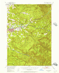
1951 Map of Sweet Home
USGS Topo · Published 1957About this map
The South Santiam River and Middle Santiam River converge in this mid-century portrait of Linn County, where timber and transit define the landscape. The Oregon Electric railroad serves as a primary corridor, winding through Sweet Home and east toward Foster, while numerous country schools like Berlin Sch and the uniquely named Over The Top Sch dot the foothills. The terrain transitions from the developed valley floor near Langmack Field to the dense timberlands of the Willamette National Forest.
Find a feature on this map
54 named features on this map. Tap any name to fly to it.
Don’t see what you’re looking for? This feature index may not catch every label — zoom into the map to look around manually.
Map Details
Editions of this 1951 Sweet Home Map
4 editions found

Other maps of this area

1921 · Brownsville
USGS Topo · 1:62,500

1921 · Lebanon
USGS Topo · 1:62,500

1922 · Lebanon
USGS Topo · 1:48,000

1924 · Lebanon
USGS Topo · 1:62,500

1929 · Mill City
USGS Topo · 1:125,000

1934 · Mc Kenzie Bridge
USGS Topo · 1:96,000

1940 · Lebanon
USGS Topo · 1:62,500

1940 · Mc Kenzie Bridge
USGS Topo · 1:125,000

1944 · Lebanon
USGS Topo · 1:62,500

1950 · Marcola
USGS Topo · 1:62,500