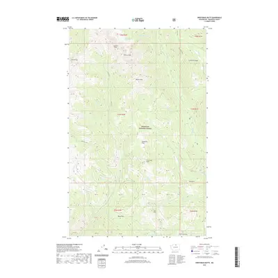
2020 Map of Sweetgrass Butte
USGS Topo · Published 2020About this map
Okanogan National Forest covers this high-elevation landscape in the North Cascades, defined by a complex network of ridges and summits. The namesake Sweetgrass Butte and Sweetgrass Ridge form the central topographic spine, while prominent heights like Sherman Peak, Sunrise Peak, and Burgett Peak mark the northern reaches. This 2020 survey details a region shaped by glacial action and water, evidenced by the high alpine Copper Glance Lake and the radiating drainage systems of Goat Creek, Eightmile Creek, and Falls Creek. Traversing these peaks requires navigating established mountain gaps such as Banker Pass, Cub Pass, and Fifth Creek Pass. The map also traces various creek systems like Roundup Creek and Ortell Creek, illustrating the remote wilderness character and drainage patterns of the Okanogan backcountry.
Find a feature on this map
48 named features on this map. Tap any name to fly to it.
Don’t see what you’re looking for? This feature index may not catch every label — zoom into the map to look around manually.
Map Details
Editions of this 2020 Sweetgrass Butte Map
This is the sole edition of this map. No revisions or reprints were ever made.
Other maps of this area

1955 · Concrete
USGS Topo · 1:250,000

1958 · Concrete
USGS Topo · 1:250,000

1962 · Concrete
USGS Topo · 1:250,000

1962 · Mazama
USGS Topo · 1:62,500

1963 · Doe Mountain
USGS Topo · 1:62,500

1969 · Mt. Barney
USGS Topo · 1:24,000

1969 · Lost Peak
USGS Topo · 1:24,000

1969 · Billy Goat Mtn
USGS Topo · 1:24,000
1991 · Rendevous Mountain
USGS Topo · 1:24,000
1991 · Mazama
USGS Topo · 1:24,000