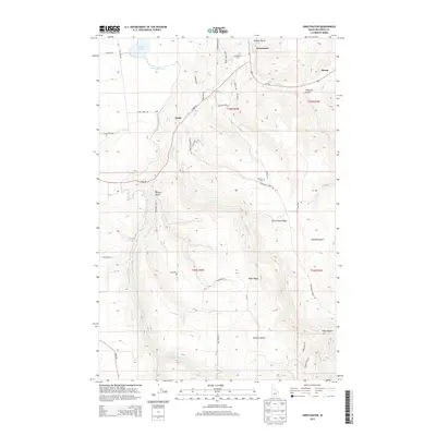
2013 Map of Sweetwater
USGS Topo · Published 2013About this map
Lapwai Valley provides the setting for this detailed topography of the Idaho panhandle, centered on the small settlements of Sweetwater and Webb. The landscape is defined by a complex network of canyons and elevated plateaus, including McCormack Ridge and Webb Ridge. Water management is a visible priority here, as evidenced by the Sweetwater Canal and the Webb Cr Canal that snake through the terrain to connect various branches of Sweetwater Cr. Genealogists and local historians will find value in the precise locations of the Sweetwater Cem and Red Elk Cem, as well as the naming of smaller geographic features like Thiessen Gulch and Polly Canyon. The transition from the lower elevations near Mann Lake to the higher ridges illustrates the distinct agricultural and residential patterns of Nez Perce County.
Find a feature on this map
46 named features on this map. Tap any name to fly to it.
Don’t see what you’re looking for? This feature index may not catch every label — zoom into the map to look around manually.
Map Details
Editions of this 2013 Sweetwater Map
This is the sole edition of this map. No revisions or reprints were ever made.
Other maps of this area

1946 · Limekiln Rapids
USGS Topo · 1:62,500

1955 · Pullman
USGS Topo · 1:250,000

1958 · Pullman
USGS Topo · 1:250,000

1958 · Lapwai
USGS Topo · 1:24,000

1958 · Sweetwater
USGS Topo · 1:24,000

1958 · Lewiston Orchards North
USGS Topo · 1:24,000

1958 · Lewiston Orchards South
USGS Topo · 1:24,000

1958 · Lewiston Orchards
USGS Topo · 1:62,500

1958 · Culdesac
USGS Topo · 1:62,500

1968 · Waha
USGS Topo · 1:24,000