
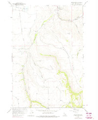
1958 Map of Sweetwater
USGS Topo · Published 1960About this map
The Nez Perce Indian Reservation Boundary bisects this late 1950s landscape, illustrating the intersection of tribal lands and early Idaho settlement. At the heart of the Lapwai Valley, the small community of Sweetwater serves as a focal point near the confluence where Sweetwater Creek meets the agricultural expanse of the Camas Prairie. The map documents a complex water management system essential for the region's development, featuring an intricate network of the Canal, a Siphon, and a Flume alongside Mann Lake.
Find a feature on this map
36 named features on this map. Tap any name to fly to it.
Don’t see what you’re looking for? This feature index may not catch every label — zoom into the map to look around manually.
Map Details
Editions of this 1958 Sweetwater Map
2 editions found
Other maps of this area

1946 · Limekiln Rapids
USGS Topo · 1:62,500

1955 · Pullman
USGS Topo · 1:250,000

1958 · Pullman
USGS Topo · 1:250,000

1958 · Lapwai
USGS Topo · 1:24,000

1958 · Lewiston Orchards North
USGS Topo · 1:24,000

1958 · Lewiston Orchards South
USGS Topo · 1:24,000

1958 · Lewiston Orchards
USGS Topo · 1:62,500

1958 · Culdesac
USGS Topo · 1:62,500

1968 · Waha
USGS Topo · 1:24,000
1968 · Winchester West
USGS Topo · 1:24,000