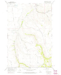
1958 Map of Sweetwater
USGS Topo · Published 1975About this map
Nez Perce Indian Reservation Boundary lines cross this landscape where the Camas Prairie meets the winding drainages of Lapwai Creek and Sweetwater Creek. The settlement of Sweetwater serves as a local hub near the Sweetwater Cemetery, while the small community of Webb sits further south along its namesake Webb Creek. A significant piece of local pioneer history is noted by the William Craig Historical Mon, honoring one of the area's earliest permanent settlers.
Find a feature on this map
35 named features on this map. Tap any name to fly to it.
Don’t see what you’re looking for? This feature index may not catch every label — zoom into the map to look around manually.
Map Details
Editions of this 1958 Sweetwater Map
2 editions found
Other maps of this area

1946 · Limekiln Rapids
USGS Topo · 1:62,500

1955 · Pullman
USGS Topo · 1:250,000

1958 · Pullman
USGS Topo · 1:250,000

1958 · Lapwai
USGS Topo · 1:24,000

1958 · Sweetwater
USGS Topo · 1:24,000

1958 · Lewiston Orchards North
USGS Topo · 1:24,000

1958 · Lewiston Orchards South
USGS Topo · 1:24,000

1958 · Lewiston Orchards
USGS Topo · 1:62,500

1958 · Culdesac
USGS Topo · 1:62,500

1968 · Waha
USGS Topo · 1:24,000